*Island Walks PDF Offer – ALL SEVEN AMAZING WALKING AREAS for just €9*
Explore the old traditional agricultural trails of the southern highlands with our ‘The Old South‘ routes; the gentle 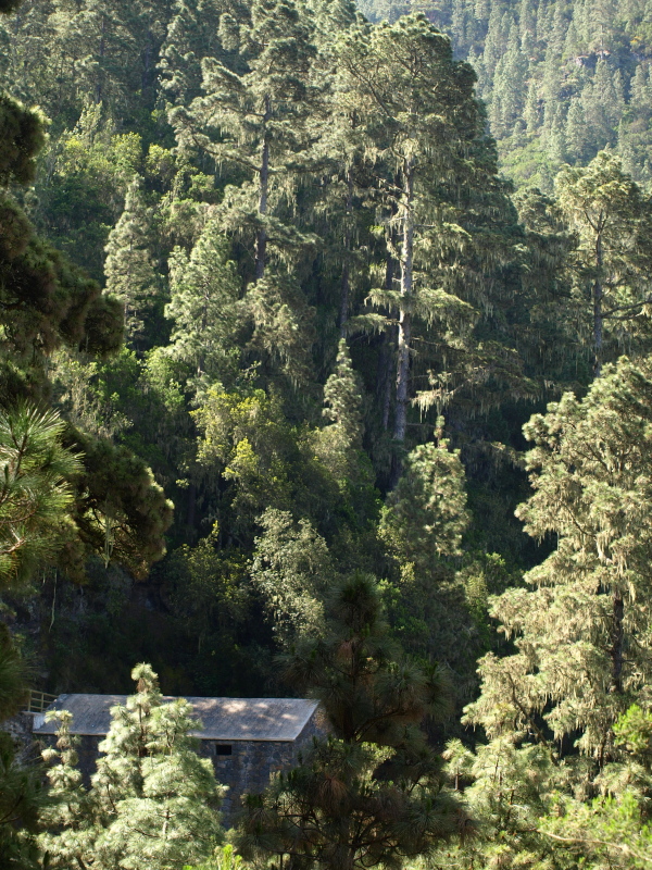 beauty of the Santiago Valley with ‘Into the Valley‘; the rugged drama of the Anaga Mountains – ‘Stepping Back in Time‘; the captivating charm of the La Orotava Valley with our ‘Northern Exposure‘ walks; a truly out of this world experience with ‘Hiking Highs‘ in the stunning Mount Teide Crater; ‘Lost Worlds & Lava‘ which reveals fascinating corners in south west Tenerife & delve deep into the Masca Barranco with the latest in our walking series, ‘West World’.
With the 5 coastal walks in ’A Captivating Coastline’ added as part of our standard free offer, that’s 28 routes through Tenerife’s beautiful countryside waiting to be discovered.
Having an unforgettable holiday on Tenerife doesn’t mean you have to spend a lot of money.
Detailed routes for all 7 walking areas €9. See below for a more detailed description of individual areas.
If you don’t have the time to explore all areas of Tenerife on foot, our Tenerife South or Tenerife North walking route packages may be more suitable. Note: both sets include Teide National Park routes.
Tenerife South Walking Routes:- Our Tenerife south set of routes reveal a very different face to an area known more for its tourist resorts. These routes take in volcanic cones, former merchants’ trails, traditional villages, ridge walks and ravines, hidden hamlets and the other-worldly drama of Teide National Park. NEW for 2019/20 season Lunar Landscape (Paisaje Lunar).
Tenerife South Walking Routes include The Old South, Lost Worlds and Lava, Into the Valley, and Hiking Highs as well as our complimentary A Captivating Coastline series of coastal walks. See below for more details on each of the walking sets.
Tenerife South Walking Routes –Route directions and interesting snippets and insights relating to what you’ll encounter en route on 15 different walking trails for only €5.
Tenerife North Walking Routes:- Our Tenerife north set of routes shows walkers Tenerife’s most verdant  landscapes, taking them from the pine forest of the upper Orotava Valley to the atmospheric and ancient laurisilva forests of the remote Anaga region. Routes climb alongside lava fields, across dramatic ravines and through sweeping valleys where life hasn’t change greatly in centuries, as well as traversing the surreal surfaces of Teide National Park.
Tenerife North Walking Routes include Northern Exposure, Stepping Back in Time, West World and Hiking Highs as well as our complimentary A Captivating Coastline series of coastal walks. See below for more details on each of the walking sets.
Tenerife North Walking Routes – Route directions and interesting snippets and insights relating to what you’ll encounter en route on 14 different walking trails for only €5.
Detailed walking routes – discover Tenerife on foot with Island Walks which you can download as soon as you make a purchase.
If you enjoy reading about our walks and want to discover the beauty of Tenerife for yourself, you’ll find Island Walks invaluable.
 Detailed instructions give you stage by stage directions with time and distance checks so that you can’t ever stray too far from the path. You’ll find invaluable advice on the type of terrain and weather conditions you’re likely to encounter on our walks; what flowers, birds and wildlife to look out for; where to finish with a refreshing beer or a nice meal and how to reach your starting point by car and by public transport – all beautifully illustrated with Jack’s photography. CLICK HERE TO SEE SOME EXAMPLE PAGES.
Tenerife Island Walks are in PDF format which you can download as soon as you make a purchase. Because they are in PDF format, you can just print off a walk when you need it and don’t have to carry an entire book of walks every time you pack the rucksack. You don’t have to worry if they get wet or torn either, just throw it away and print off another next time you need it.
As well as covering what we consider to be the best walking on Tenerife, our routes include interesting facts, photographs and quirky snippets to give you a complete guide to the countryside and access to places which most visitors never see.
Check out our Frequently Asked Questions (FAQ) page for advice about which routes will suit you best depending on which resort you are staying in. For more information on how we grade individual walking routes, read this.
 Anaga Mountains – Stepping Back in Time (circular routes)
Simply Stunning: Three of our favourite walks on Tenerife include dappled ancient forests, plunging barrancos, quaint hamlets, old merchant trails, a troglodyte community and incredible views of a landscape which looks much the same as it did when the original Guanche inhabitants of Tenerife walked these same paths and the post conquest settlers planted their first crops.
Routes Difficulty level 3 – a good thigh muscle workout but within the range of reasonably fit walkers.
Where: Anaga Mountains – North Tenerife; Distance: 11.2, 11.7 & 13.3 kilometres; Time: 3.5 hours & 4hrs 50 mins.
Santiago del Teide – Into the Valley – Erjos Pools, Santiago del Teide & Arguayo Lovely walks through a breathtaking landscape. Easily accessed from most of the main resorts and a hop, skip and a jump away from those in the Los Gigantes area, these routes traverse the wonderful Erjos Pools and the Valle de Santiago; a place whose natural beauty has defied the destructive forces of volcanic eruption and forest fires. The sweeping valley is home to small farming hamlets where crops are still picked by hand and has spectacular views of Mount Teide, La Gomera and La Palma.
Main Route Difficulty two routes are level 3 – a good work out, but within the range of reasonably fit hikers; one small route is a level 2.
Where: South West Tenerife; Distance: Valle de Arriba 14.3 kilometres; Pools & Pines 6 kilometres. Times: Route 1 is 3 hours 50mins; Route 2 is 2 hours 15 mins.
 La Orotava – Northern Exposure – Around La Caldera and Aguamansa (circular) The La Orotava Valley has charmed explorers and naturalists for centuries and any routes around the upper valley shows walkers exactly why. One route heads into the forest and up into the higher reaches of La Orotava for some incredible views of the valley and Mount Teide from enchanting forest paths. A second route takes you through the pine forest and rural farmlands while the third follows an old Guanche trail through the forest with amazing views over the north west coast.
Main Route Difficulty level 4- a good decent workout with some challenging sections near the start; route 2 is level 2 – no serious ascents or descents; route 3 is level 3 – a good thigh muscle workout, but within the range of reasonably fit walkers.
Where: North Tenerife; Distance: Route 1 is 11.8 kilometres; route 2 is 7.5km; route 3 is 15km Time: Route 1 is 4 hrs 20mins; route 2 is 2hrs 20mins; route 3 is 4hrs 45mins.
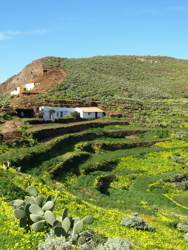
Adeje, Arona & Abona – The Old South – Adeje Mountains, Barranco del Infierno, Los Cristianos, San Miguel and Vilaflor (Lunar Landscape – Paisaje Lunar NEW for 2019/20 season). A wonderful opportunity totake a trip back in time and discover the character of the south of Tenerife before tourism dominated its coastline. In the hills above Playa de las Américas and Costa Adeje is a landscape dotted with hamlets and agricultural terraces which feels far removed from the modern resorts which are occasionally stunningly visible from ancient summits and old merchants’ trails.
Difficulty level 3 – walks are all well within the range of reasonably fit walkers.
Where: South Tenerife; Distance: 6 routes ranging from 3 to 13 kilometres in length; Time: walks up to 4.5 hours.
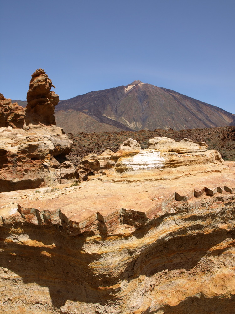 Teide National Park – Hiking Highs – Mount Teide Crater Walking in the Mount Teide crater is unlike walking anywhere else in the world. Spain’s highest mountain dominates, whilst weird and wonderful volcanic rock formations create an incredible landscape above the clouds that is a wonder to explore on foot. Follow in the footsteps of Greek mythological heroes (Clash of the Titans was filmed here) and leave the crowds in the tourist spots in the crater way behind.
Difficulty level: 3 routes are level 3 – Good thigh muscle workout with some strenuous ascents or descents but within the range of reasonably fit walkers; one route is level 4 – Invigorating and demanding with testing ascents or descents and some rough terrain, and the ultimate Tenerife walk, climbing Teide, is level 5 and only for fit & experienced walkers.
Where: Teide National Park; Distance: Routes are 8-10 kilometres in length; Time: From 2 hours to 6/7 hours (Mount Teide)
South West Tenerife – Lost Worlds and Lava – The Lost Village of Las Fuentes, Chinyero and Güía de Isora to Chirche. Uncover the ghosts of an agricultural past in the hills above Tenerife’s sunny south west coast. From abandoned terraces and disused kilns, through the cobbled streets of sleepy hamlets to a lost village where 150 people once lived, and the breathtaking beauty of the site of Tenerife’s last volcanic eruption – Chinyero. Three very different faces to the south west with views over the coast from Playa Paraíso to Playa de la Arena with the neighbouring island of La Gomera on the horizon.
Difficulty Levels 1 and 3 – ranging from virtually flat terrain to undulating valleys with a couple of short climbs to spectacular views. All well within the scope of any reasonably fit person.
Where: South West Tenerife; Distance: One route is 5.5 kilometres, the other two are 7 kilometres in length; Time: All routes are 2 to 2.5 hours.
West Tenerife – West World – Masca, Teno Alto & Garachico.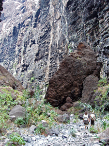
From descending into the ancient and atmospheric Masca Barranco to experience one of Tenerife’s most popular and breathtaking walks to going off the hiking beaten track to explore some divine countryside in a peach of a valley West World is another enchanting series of Tenerife walking routes. Whilst Masca is simply a must, our Teno Alto route is one of our favourites and as a bonus you get the chance to buy some goat’s cheese that packs a flavour-filled punch.
Difficulty Levels 3 & 4 – although the walks aren’t particularly lengthy, the terrain involves quite steep ascents. With Masca the terrain can be quite challenging in parts.
Where: West Tenerife; Distance: Routes range from 5.5 to 10.5 kilometres ; Time: From 2 hours to 5.5 hours.
 A Captivating Coastline – FREE with any purchase Some parts of Tenerife’s coastline are simply breathtaking in their beauty and many coastal paths are accessible for most people. From hidden coves and lush palm groves to cobbled paths and grand old mansions; rock pools and cyan seas to dramatic cliff top paths, our ‘A Captivating Coastline’ guide includes our top five favourite coastal walks on Tenerife.
We will send you a complimentary copy of A Captivating Coastline following any purchase of Island Walks, Town & City Walks, Real Tenerife Island Drives
Easily view and print ‘Tenerife Island Walks‘ with this free software
In order to view and print your single route PDF itinerary you need Adobe Acrobat Reader software. If you don’t already have Adobe Acrobat installed on your PC, click the image for your FREE download.

We’ve not visited Tenerife before. Please could you recommend; should we hire a car; where we should stay and any long walks in that area?
Thank you
It’s a difficult question to answer without knowing your personal preferences. For example, the purpose built resorts couldn’t be more different from the historical towns or the cities. There are good walking routes near to most places but, generally speaking, the best walking is in northern and western areas. Have a look at our question and answers page which might give you an idea and then if you have any further questions, feel free to ask.
Hi,
I have just bought one of your guides. When can I expect to receive it? I’m leaving to Tenerife in a couple of hours so I’d be grateful if I could get it ASAP.
Best regards,
Michal
I hope you got it on time Michal. The guide was sent before I saw this message.
For anyone else who may see this comment, when you buy any of our guides there is an option of being able to add special instructions when you place the order.
A friend has told me that the Los Organos path is closed and affected by more rock falls. Do you have any up to date info about this? Thanks! Ros
Part of the Los Organos path was closed last year because of problems with the state of the path. A couple of friends walked it in November, after it was closed, and although it was still passable, they thought it was quite dangerous. We’d hoped that the authorities would have fixed the issue given the first Tenerife Walking Festival was this year (just finished) but the official information shows that part of it is still closed.
We’ve added an alternative new route to our walks which gives walkers very similar views as the Organos one but isn’t as vertiginous.
Good day i am looking for 3-4 days hiking trip in canary islands end of october 2015!
Hi Jack and Andrea
I’m intending to escape the coast with a 2/3 day walk, probably finishing at Los Christians, (or Playa las Americas). My idea is to go up from Santiago di Tiede and come down via Viaflor. I cannot find any walks which traverse this route.
I was intending to sleep out (bivouac) for one or two nights, if necessary. This would take the time pressure off, and the necessity for a car.
I arrive on the 15/1/15.
Can you recommend any of your walks which include or would cover this intended line? Also which map would be best?
Many thanks and best wishes for 2016.
Ian
Hi Ian,
That’s an interesting route. Last year we actually looked at a similar route but going in the opposite direction from San Miguel de Abona above the south east coast to Santiago del Teide via Vilaflor and Teide National Park.
We were putting together an itinerant walking holiday for UK walking holiday specialists Inntravel. In the end we decided against the link to Santiago del Teide as there was no natural link between the park and Santiago del Teide. There are trails everywhere, but as most used to be mainly trading routes or paths to move livestock between coast and sea they tended to go up and down or link communities so there was never any real need for a link between the Santiago side of the park and the crater. It’s a shame because it would be a very diverse route. You can get to the road through the park via Chinyero but there are no established paths from there linking that particular section with the routes to Vilaflor. For every other part there’s a choice of paths.
Unfortunately I don’t think any of our routes would be much use as we tend to have circular routes where possible as most people who buy our routes get to the starting points by public transport or car.
I’d recommend trying the Kompass map to piece together a route. It isn’t perfect (none of them are) but it’s not bad.
Hope you manage to work it out and Happy New Year.
Hi, could you tell me if the book ‘Walk this Way’ has the same walks in as the 7 Island Walks pdfs?
Which resource would be more suitable for 2-4 hour walks in South and West of Island (we r staying at Alcala)?
Thanks
Hi Fiona,
All the walks in the pdfs are in the guidebook, the book simply has more additional information about the island as well as a few walks not included in the PDFs. If you only want walks covering a specific area a couple of the PDFs would suit best. The closest to Alcala are the Into the Valley routes which are around Santiago del Teide which isn’t far inland from Alcala and includes a great walk which falls into the 2-4 hour category. Also the Lost Worlds and Lava routes are above the south west coast and all three routes are between 2-4 hours.
I am very interested in buying Real Tenerife Island Walks & also possibly Real Tenerife Island Drives. I am living in South Tenerife this year but do not have a printer to print off the walks & drives.
Can I buy the books from a bookshop here?
I look forward to your reply.
Regards
Rosemary Cocker
Sorry for the slow response Rosemary, we’ve been in the field, so to speak, for most of the last week. Both Island Walks and Island Drives are only in PDF format. We did stock a book version of the drives in shops here for a while but were unhappy with the organisation of distribution.
We do have other books in print form, including our walking guidebook Walk this Way Tenerife (a more comprehensive version of the Island Walks routes with additional routes and useful information) but these are only available from Amazon and other online bookstores.
I am looking for walking guides for a beach to Tiede summit walk over a week in September 2016. Route starting at Masca valley. Hopefully avoiding road walking. I am an experienced altitude walker. The information available on line is not clear to me. I plan to use public transport / taxis to Los Gigantes hotel each day.
It’s not an established route which is why you’re struggling to find clear information about it. Many of the best routes on the island have been around for centuries and existed for a purpose; however, the more personalised the route, the less information you’ll find. There are coast to Teide summit routes, but not from that starting point.
We often piece together walking routes for various reasons and just about anything is possible (not without some road walking in the case of the route you want to follow) but these involve quite a bit of planning and testing to sew them seamlessly together.
All I can advise is to get hold of a decent walking map and try to create the route you want on that first. Tenerife walking Maps aren’t perfect but they do tend to show where most paths exist.
Having to return to Los Gigantes each day makes it significantly more complicated. The more rural the area the more infrequent the bus service so you’d probably need to come to an arrangement with a taxi firm in your resort.
Hi
Can you tell me if GPS tracks are available for download for the ‘Walk This Way’ guide?
many thanks
Hi Zinnia,
There are some GPS coordinates for route starting points in the print guidebook, but that’s all. To be honest, although we use a Garmin to record routes we’ve not included them in the past because we believe it’s important the routes are more about descriptors and not reliant on GPS.
But more and more people like GPS and in future we’ll be including more coordinates.
Hi, we are coming to Costa Adeje on 15/10. We would like to do some walking, anything up to 7 miles. We walk at home in the Yorkshire Dales etc, but have our 14 year old with us who is not as keen as us, so will keep the walks shorter. We do not have a car. I was planning on venturing to the north of the island but now on looking at the bus routes it looks like the journeys will be long. Could you recommend which routes I purchase for download. Thank you
We’ve just booked a week in January at Los Gigantes and would like to include some decent length walks from the resort. Will the Lost Worlds and Lava walking routes give us the info we need?
Thanks, regards, Jonathan
Hi Jonathan and apologies for the late reply, I’ve only just noticed your comment. If you’re hiring a car then the Lost Worlds and Lava routes are certainly easy enough to reach. They can also be reached by public bus (we include relevant bus routes) but it would be a lot more complicated. Easier whether driving or using public transport are the Into the Valley routes in and around Santiago del Teide which is about a 15/20 minute drive up the hill from Los Gigantes. There’s also a direct bus service linking Los Gigantes with the Santiago del Teide area.
Thanks Jack – Into the Valley routes map ordered.
Hello, Jack
Thanks for an interesting and informational site! I’m going with a friend to tenerife in the end of Feb- beginning of March. We’re interested in doing some walks. We’re more into interesting plants and flowers and charming paths than peek views and altitudes. At this time of year- could you recommend which of your routes would be suitable? We lean towards staying somewhere in the north around Puerto de la Cruz.
Best regards from Karoline
Hello Karoline,
We tend to favour routes which are visually interesting in a number of ways because that’s what we like ourselves, so the northern ones especially include a variety of different plants and flowers. You might catch the end of the almond blossoming period in our Into the Valley routes around Santiago del Teide and possibly even the start of the spring wild flower season. Similarly our West World routes include some interesting fauna, especially the Teno Alto route. And walks in the upper Orotava Valley (Northern Exposure) are different again. Puerto de la Cruz is the ideal base for anyone who plans on walking, it’s where the annual Walking Festival is based.
Hope this helps,
Jack
Hi
We hav around 10 days on tenerife this December, from the 9th to the 20th. We want to spend half our time hiking and half visiting some lovely caostal areas and some lovely towns and viallages. We want to avoid all the pavcakge touris at all costs, I assume this is all on the sotuh and south west coast? Anyway, could you perhaps reccomend about 4 towns where we could base ourselves over the 10 days that will have acces to some of the best walks, we are fit and experinced hikers. We will more than liley hire a car, so would like to see a good mix of what is on offer. Thanks you in advance, Fiona
Hi,
I just paid for the hiking and the driving guides, but don’t know what to do next… Could you give me instructions?
And using this opportunity, I have one question. I would love to spend maybe three days hiking in the north east of Tenerife, before driving down to the south. Could you give me advice as to where is a good place to stay and use as a base. I currently plan to stay in La Laguna, and drive to the entry/exit point of hiking routes every day. Do you think this is a good strategy, or do you have a better idea?
I am looking forward to reading! Thanks!
Hi Makoto, you should have the guides by now. La Laguna is the best town base for accessing walking in Anaga as the main route into the mountains starts right from the outskirts of the town. There is also a hostal actually in the Anagas, Albergue Montes de Anaga, which is perfectly placed for getting to walking routes. Hope you enjoy the walking there, we always do.
Hi, i just paid via Paypal but received no confirmation, is this normal and when will i get the pdf? Thanks!
Hi Tanja,
You should have received confirmation of purchase with an order number from Paypal. We’ve received notification and the routes have been sent to your email address.
Hello Jack,
Great site you have here! Going to Tenerife during the 2nd week of October for a large week, sleeping in Airbnbs in Puerto de la Cruz and San Andres and looking both for some great hikes and some relaxing beach moments 😉
Can we buy the entire book in PDF format so we can indeed split chapters up? Or it’s not possible and the choice is between (1) The complete book OR (2) The PDF routes (not complete)
Btw hiking is best advised early in the morning I guess, to avoid the heat?
Looking forward to discovering Tenerife off the beaten track!
Thanks in advance,
Stefanie
Hi Stefanie,
The guidebook isn’t in PDF format, sorry. But the range of PDF routes do cover most of the routes in the guidebook. Over the course of a week you’d be able to get in some of the best walking on the island just by choosing from those, obviously depending on where you stay, and can access. Setting off in the morning is always good advice for Tenerife, but by October you don’t have to set off too early. It’s a great month for walking as it’s still late summer warm, but usually not searingly hot.
Jack
Hi Jack, bought you guide a couple of months ago. It’s awesome! Helped us out a lot to plan which hikes we want to do. I read online that there were problems with the Los Organos route. It was closed due to rockfalls, but now apparently it’s open again (though not officially?). Do you have any more information about this as I can’t find much online and I’d love to hike that trail.
Thanks!
Reallly glad you like the guide. The Los Organos route is open – here’s an account of walking it from last April.
So, I just got back from Tenerife. We had a great time, lots of hiking. The guide I got from this site proved very valuable and helped us a great deal with not getting lost. 🙂
Some feedback about the hikes we did :
– The Barranco del Infierno : we felt it was a level 2 trail, only the warm sun might make this a level 3 trail.
– Above the Barranco Del Infierno : nice easy trail, hard to get lost.
– Masca Barranco : VERY nice trail, probably one of the nicest hikes we’ve done in a long while. Hard to get lost.
– To the Hidden Valley of Las Fuentes : the trail itself is not that interesting, but the village of Las Fuentes at the end was very cool to see!
– From the Forest to the Caves : we started in Punta Del Hidalgo, took the trail to Chinamada and were planning to go to Cruz del Carmen from there. Sadly we took the wrong path in Chinamada and ended up in Los Batanes (also a very nice hike). From there we followed the road to Cruz del Carmen to reach our pickup. There was a signpost in Chinamada saying Cruz del Carmen and only one trail that started there, so we still don’t know how or where we went wrong, just wanted to point this out for others to watch out for this.
– We wanted to do the Los Organos route, but due to heavy rain ended up doing A Glimpse of Rural Life. That route was alright, but due to the weather we didn’t really have any great views.
Sadly we couldn’t do all of our hikes due to the weather (El Teide was closed the entire week due to snow and temperatures well below 0°C), so we’ll have to go back at some point to finish those.
– Los Organos : we had very heavy rain shortly after we started and decided not to take any risks. The views would have been poor anyway.
– The hike up mount Teide : all routes to the volcano were closed, so we had to skip on this one sadly.
– From El Palmar to Teno Alto : also couldn’t do this one due to bad weather in that region during our final days.
– I’d also like to do another hike in the Anaga region, that was really pretty.
So with respect to doing those remaining hikes, when would you suggest is the best month for those? An ideal hiking temperature would be below 20°C, no rain and clear skies. I’ve heard from people that april/may is good and also october/november. In your experience, when would you advise us to go back? Thanks!
Many thanks for the feedback Filip, really useful. Unfortunately the bad weather which rolled in across the Canaries scuppered a lot of hiking plans over the last couple of weeks. We were also thwarted, having to cancel plans to check directions on a couple of routes.
One of the ones we did manage before the snow and rain moved in was Las Fuentes. The prolonged spell of dry weather has left some parts of the south west looking not as attractive as they should at this time of year. We were also disappointed with how Las Fuentes was looking. Rain will transform it, but the authorities have also ‘tidied’ part of the route up, not improving it in the process.
You were just unlucky with the weather, these sort of weather fronts will hit a couple of times during the season, you just never know when. Proximity to carnival is usually a good measure though 🙂 You can still get some rain in April/May but not the sort of weather you experienced on this trip. Spring is our favourite time for walking. That Teno route is especially beautiful when the wild flowers are in bloom. October is also good, but can still be very warm. November can be dodgy. Could be perfect, but change of season heavy rain comes at some point.
Hi – I’ve just ordered the pdf guides and will be heading out to Tenerife very early Monday a.m.12th March. Was planning to do the Masca Barranca gorge amongst other trails but understand this has been closed for the time being, so looking for some alternatives. Just wanted to check that the guides will be e-mailed through within 24 hours i.e. by Sun evening please 11th March. Many thanks – really appreciate it. Dave W
Most walking routes on the island are open, Masca is only closed because it’s such a busy route, and people were still attempting it under dangerous conditions (weather alert level wind and rain). There’s been a lot of injuries in the barranco because too many people aren’t suited to the terrain so the authorities are trying to make it safer. I’d recommend travelling a bit further into the Teno Massif and trying the Teno Alto route, it’s one of our favourites and at its best at this time of year… and you don’t get the Masca crowds. In truth there’s plenty, we only include routes we particularly like. Hope you enjoy the walking.
Just to thank you for all the thought, care, hard work and passion that has gone into compiling your walk book. I have used it for two trips to Tenerife now, and have found the instructions to be clear and accurate (as are your observations!).
I’m just back having had a wonderful week admiring all the Spring flowers. I even saw oil beetles (https://en.wikipedia.org/wiki/Meloe) at Las Moradas. I’ve only ever seen these once before in the UK – they are very rare, but apparently
love the wilderness of Tenerife!
Is there any chance of a Volume 2 for me to explore?
Thanks for the well priced and great guide, I would recommend it for sure – even without detailed maps and GPS, we found all the trail heads trails as needed. One thing I would like to point out though, is that many of the trails in this “select” guide are HEAVILY used, some even require reservations and cost money. Having grown up in western Canada, hiking and camping, I am keenly aware of how we must all be stewards of our forests and trails. However, many of these select trails are just being hammered by tourists, garbage, faeces, etc. I think it would be great if the authors could help disperse this heavy use to other less used regions and trails by showcasing routes that are not so widely known. I think it may be worth the authors time to ponder their contribution to the overuse of these trails and instead help to spread out the impact and even add a few lines about clean and responsible hiking. Judging by the quality of this guide I am sure you would do a great job and it would be much appreciated by everyone. Happy Trails.
Hi Jesse,
Thanks for the feedback, it’s appreciated and you’ve given us a couple of ideas. I’d be interested to know which routes you walked? Currently there is only one route on the island for which there is a charge, the Barranco del Infierno. It’s not one of our favourites but it’s highly popular due to its proximity to the main resorts. The summit of Teide National Park requires a reservation, but that’s for conservation purposes so understandable. The only other route which requires a permit is in Anaga in the north east, but we don’t include that one. Generally speaking, walks which are easily accessed from the main southern resort areas tend to be busiest, with Masca being a particular example of a great route which is negatively affected by the amount of walkers, an issue we’ve written about many times. It’s recently been closed as a result of ‘hiker abuse’. But most other routes remain crowd free which is why we include them so I was really surprised at your comment that many of the trails are “being hammered by tourists, garbage, faeces”. That has not been our experience… apart from the ones mentioned above and a couple of trails in Teide National Park. Teno, Anaga, and the Orotava Valley, where our favourite walks are located, are too far away from the main resorts so don’t get the same volume of visiting walkers even in high season and we love walking in those areas because of that and because of their beauty. Again thanks for your comments – food for thought – and I’d love to know where you walked so we can look at those areas again.
Thanks Helen,
With the temps generally still not too hot and the wild flowers in bloom it’s our favourite time for walking. Sadly volume 2 is highly unlikely. We’ve been too busy writing walking routes for the other Canary Islands and also various destinations around Europe for a UK based Slow Travel company. Sorry. But I hope there are still some routes left for you to explore 🙂