Walking in the upper La Orotava Valley we passed a young German couple enjoying the route in the opposite direction. We said hello, or more accurately Buenas Tardes (when in Rome and all that) and carried on.
About an hour and a half later, and about thirty minutes walk from the end of the route, we were stopped in our tracks by somebody shouting at us. It was the young German couple. The girl came running through the forest to join us.
“Hi again, can you help us? Do you know the way to La Caldera?” She asked.
“Err, yes…I hope so anyway,” I replied, I wasn’t yet 100 percent convinced that we were definitely on the right track ourselves – there are a lot of intersecting paths in those woods. “But I thought you were going in the other direction?”
“We were,” she laughed. “But the descent looked very dangerous, so we turned back. But now everything looks very different in this direction.”
At that point her boyfriend/husband/pal joined us. He had a map in his hand. He looked at it, turned it on its side and looked at it again, then stared at the path ahead.
“We are wanting to go here,” he pointed at a tent symbol on the map.
“Can I have a look?”
He handed me the map.
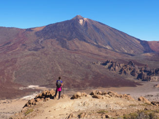
It was a good map of Tenerife for sure, one of the better ones I’d seen. It had the La Caldera zona recreativa marked on it, but it wasn’t Ordnance Survey. Apart from the little tent to show there was a camping area at La Caldera, there weren’t any paths shown through the woods; the scale was far too small. As a walking guide it was useless. A one way ticket to ‘getting lostville’.
 At the junction where we stood there were paths leading in four directions; none were signposted.
We pointed them in the right direction and they went off at a pace; they’d clearly had enough of their time traipsing around woods.
Tenerife is a fantastic place for walking, but even if you’re an experienced walker, you do have to be prepared. Routes can start off with clear signposts pointing to wide tracks and then, when you’re deep in the forest, the tracks and the forest floor can gradually blend into one another and signposts annoyingly go missing.
A standard map, even a relatively detailed one, just isn’t a good enough tool for helping people find their way around the countryside, you need an Ordnace Survey map and/or clear, reliable directions.


Just read this post re. Ordnance Survey maps. I’m off to Tenerife in March and have just bought your set of walks. In the UK, I would always carry an OS 1:25,000 map as well – would you recommend one to accompany your guides too?
I’m likely to be walking alone (he doesn’t think much of walking…). How safe is this?
C
Hello Corinne,
We’ve been researching on Lanzarote and I’ve only just seen your comment. I’d say that if you were walking without directions then you would need an OS equivalent map. However, the closest thing to those here are the Spanish Army maps which are quite out of date to be honest. Because of the climate, paths can become overgrown and disappear rapidly on Tenerife – so even the most detailed map is out of date almost as soon as it’s produced.
Saying that, there’s no need to have a detailed map on our routes. We concentrate on clear directions that are broken down into stages to make following them that little bit easier. Living here we’re able to regularly check that they’re up to date and routes still exist.
As far as safety is concerned (apart from taking the usual precautions in case of an accident whilst walking alone) Tenerife is very, very safe for walking. People are very friendly and respectful, so you should have no worries there.
Thank you Jack,
that’s very useful.
Hope you enjoyed Lanzarote- I love it: the scenery is so unusual and startlingly beautiful. Lots of nice quite places to stay off the beaten path too. We published our Lanzarote website a little while ago http://www.vrcanaries.com/
OOOPS -sorry, that previous reply looks like I am putting free advertising on your site, which is a bit cheeky! Feel free to remove it. I just thought you might be interested…
We enjoyed it immensely. It had been 20 years since our last visit (which hadn’t been our most memorable trip abroad) and saw it with completely different eyes this time. I loved the contrast of the low rise white buildings against the volcanic landscape.
Didn’t cross my mind at all…and it is interesting to see : )